


का विवरण SkyDemon
SkyDemon is one of Europe's most popular solutions for VFR flight planning and in-flight navigation.
Use this app to access your SkyDemon subscription on your Android device, unlocking SkyDemon's powerful features while on the move.
FLIGHT PLANNING FEATURES
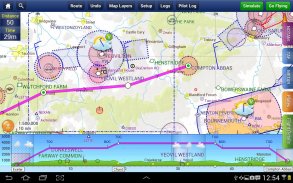
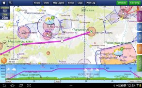
- SkyDemon vector charts are the clearest aeronautical charts you'll ever use, with dynamic airspace clipping and choice of map layers
- Route planning is as simple as touching consecutive waypoints and dragging to make changes
- Virtual Radar shows how your route relates to airspace, terrain, obstructions and other features
- Pilot Log facility calculates headings and groundspeeds from actual wind data, and shows useful frequencies
- Plates and other documents for relevant airfields are displayed automatically as you plan, and many are available georeferenced for use in flight
- Intuitive pan, pinch and rotate support with no loss of map clarity or text legibility
- File a VFR flightplan for your route directly to air traffic controllers
- Automatic TAF, METAR and SIGMET briefing as you plan a route, with graphical decoding
- Rainfall data can be overlaid on the main map, with animation, showing the trend of rainfall over time
- Integration of GAFOR route forecasts for Switzerland, Austria, Slovenia and Croatia
- Both narrow-route and area NOTAM briefings available, updated as you plan
- Advanced NOTAM graphical interpretation and depiction on the main map
- Easily print your PLOG and the output from various briefings
- Warnings for airspace and other potential hazards to your flight, updated in real time
- Airfield Admin Information shows useful contacts and other details for airfields featured in our charts
- Forecast winds aloft are automatically retrieved for the flight time and displayed on the map
- Create an advanced flight performance profile for each aircraft you use
- ATS Routes mode offers an alternative chart presentation for flight along airways
- Accurate fuel, weight and balance calculations including flight costings
- Create an unlimited number of user-defined waypoints
- Analyse your track logs for posterity
- Choose between six different vector chart styles
- Extensive European chart coverage as standard
GPS NAVIGATION FEATURES
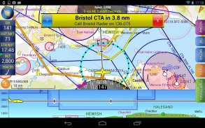
- Intelligent warnings for approaching airspace, NOTAM, obstacles, terrain and other hazards
- Virtual Radar shows a side-on projection of all approaching features and how your trajectory relates to them
- Vector map automatically follows the aircraft in north up, track up or course up orientation
- Clear and concise instruments show you flight statistics and help keep you on track
- An HSI/ILS instrument helps you keep to your planned route and line up early for approach
- Live Pilot Log shows progress through your route, ETAs, ATAs and useful frequencies based on your current position
- TerrainSafe dynamically colours mountainous terrain around you to quickly identify safer areas
- Direct To allows easy re-routing in a hurry by picking from a selection of nearby airfields
- Approach Information shows runway diagrams, TAF, METAR, NOTAM and other airfield details useful for making an approach
- Live updates of TAF and METAR while in flight, with associated alerts*
- Extended runway centrelines appear automatically on the map as you near your destination airfield
- Permanent display of position relative to nearest well-known waypoint, for position reporting
- Easy changing of the planned route while in flight by touching and dragging
* Internet connection required for live weather update while in flight
SkyDemon VFR उड़ान योजना बनाने के लिए और नेविगेशन में उड़ान यूरोप के सबसे लोकप्रिय समाधानों में से एक है।
, अपने एंड्रॉयड डिवाइस पर अपने SkyDemon सदस्यता का उपयोग करने के लिए SkyDemon के शक्तिशाली सुविधाओं का ताला खोलने, जबकि इस कदम पर इस अनुप्रयोग का प्रयोग करें।
उड़ान की योजना बना फीचर्स
- SkyDemon वेक्टर चार्ट स्पष्ट वैमानिक चार्ट आप कभी इस्तेमाल करेंगे, गतिशील हवाई क्षेत्र कतरन और नक्शा परतों के विकल्प के साथ हैं
- मार्ग नियोजन लगातार waypoints छू और परिवर्तन करने के लिए खींच के रूप में सरल है
- आभासी रडार से पता चलता है कि कैसे अपने हवाई क्षेत्र मार्ग, इलाके, अवरोधों और अन्य सुविधाओं से संबंधित है
- पायलट लॉग सुविधा वास्तविक हवा डेटा से शीर्षकों और groundspeeds खरीदते हैं, और उपयोगी आवृत्तियों से पता चलता है
- प्लेट्स और प्रासंगिक हवाई अड्डों के लिए अन्य दस्तावेजों स्वचालित रूप से प्रदर्शित कर रहे हैं के रूप में आप की योजना है, और कई उड़ान में इस्तेमाल के लिए भू-संदर्भित उपलब्ध हैं
- सहज पैन, चुटकी और नक्शा स्पष्टता या पाठ स्पष्टता की कोई हानि के साथ बारी बारी से समर्थन
- हवाई यातायात नियंत्रकों के लिए सीधे अपने मार्ग के लिए एक VFR Flightplan फ़ाइल
- स्वचालित TAF, METAR और SIGMET ब्रीफिंग आप चित्रमय डिकोडिंग के साथ एक मार्ग की योजना के रूप में,
- वर्षा डेटा मुख्य मानचित्र पर मढ़ा जा सकता है, एनीमेशन के साथ, समय के साथ वर्षा की प्रवृत्ति दिखा
- स्विट्जरलैंड, ऑस्ट्रिया, स्लोवेनिया और क्रोएशिया के लिए GAFOR मार्ग के पूर्वानुमान की एकता
- दोनों संकीर्ण मार्ग और क्षेत्र NOTAM उपलब्ध ब्रीफिंग, के रूप में आप की योजना अद्यतन
- उन्नत NOTAM चित्रमय व्याख्या और मुख्य मानचित्र पर चित्रण
- आसानी से अपने PLOG और विभिन्न ब्रीफिंग से उत्पादन मुद्रित
- हवाई क्षेत्र और अपनी उड़ान के लिए अन्य संभावित खतरों के लिए चेतावनी है, वास्तविक समय में अद्यतन
- एयरफील्ड व्यवस्थापक सूचना हमारे चार्ट में विशेष रुप से हवाई अड्डों के लिए उपयोगी संपर्क और अन्य विवरण से पता चलता है
- पूर्वानुमान हवाओं ऊपर स्वचालित रूप से उड़ान समय के लिए लिया गया है और नक्शे पर प्रदर्शित कर रहे हैं
- प्रत्येक विमान आप उपयोग के लिए एक उन्नत उड़ान प्रदर्शन प्रोफ़ाइल बनाएं
- एटीएस मार्गों मोड एयरवेज के साथ उड़ान के लिए एक विकल्प के चार्ट प्रस्तुति प्रदान करता है
- उड़ान costings सहित सटीक ईंधन, वजन और संतुलन गणना
- उपयोगकर्ता परिभाषित waypoints के एक असीमित संख्या बनाएँ
- भावी पीढ़ी के लिए अपने ट्रैक लॉग का विश्लेषण करें
- छह अलग वेक्टर चार्ट शैलियों के बीच चुनें
- व्यापक कवरेज चार्ट यूरोपीय मानक के रूप में
जीपीएस नेविगेशन सुविधाओं
- करीब पहुंच हवाई क्षेत्र, NOTAM, बाधाओं, इलाके और अन्य खतरों के लिए बुद्धिमान चेतावनी
- आभासी रडार सभी के करीब पहुंच सुविधाओं के एक पक्ष पर प्रक्षेपण से पता चलता है और कैसे अपने प्रक्षेपवक्र उन से संबंधित
- वेक्टर नक्शा स्वचालित रूप से उत्तर में विमान प्रकार है, अप ट्रैक या पाठ्यक्रम की ओर रुख
- स्पष्ट और संक्षिप्त वाद्ययंत्र आप उड़ान के आँकड़े बताते हैं और मदद से आप ट्रैक पर रखने
- एक एचएसआई / आईएलएस साधन आप अपनी योजना बनाई मार्ग को रखने के लिए और दृष्टिकोण के लिए जल्दी लाइन अप में मदद करता है
- लाइव पायलट लॉग अपनी वर्तमान स्थिति के आधार पर अपने मार्ग, ETAS, ATAs और उपयोगी आवृत्तियों के माध्यम से प्रगति को दर्शाता है
- TerrainSafe गतिशील रंग पहाड़ी इलाके आप जल्दी से सुरक्षित क्षेत्रों की पहचान करने के लिए चारों ओर
- डायरेक्ट के लिए पास के हवाई अड्डों की एक चयन से उठा कर जल्दी में फिर से मार्ग आसान की अनुमति देता है
- दृष्टिकोण सूचना रनवे आरेख, TAF, METAR, NOTAM और अन्य विवरण हवाई क्षेत्र एक दृष्टिकोण बनाने के लिए उपयोगी चलता
- उड़ान में जबकि TAF और METAR का लाइव अपडेट, एसोसिएटेड अलर्ट के साथ *
- विस्तारित रनवे centrelines अपने गंतव्य के हवाई क्षेत्र के पास के रूप में नक्शे पर स्वचालित रूप से दिखाई देते हैं
- निकटतम प्रसिद्ध waypoint के सापेक्ष स्थिति, स्थिति के लिए स्थायी प्रदर्शन रिपोर्टिंग
- छू और खींचकर उड़ान में है, जबकि योजना बनाई मार्ग के आसान बदलते
* इंटरनेट कनेक्शन को लाइव मौसम अद्यतन के लिए आवश्यक है, जबकि उड़ान में
SkyDemon - Version 3.16.12
(14-02-2024)SkyDemon - एपीके जानकारी
एपीके संस्करण: 3.16.12पैकेज: aero.skydemon.skydemonandroidApps in the same category
You may also like...


